 route appears on the Puncaktrek map for Ciawi (sector B).
We crossed 9 valleys, including two very broad ones, the Ciherang and the Cikereteg. Amazingly, after a hiatus of at least 7 years (in some places 10), the route is intact in all but one valley, a branch of the Ciherangsatim. In that small valley (the second from Cipare), previously planted in sawah, the land now belongs to Pk Rosadi of Bogor, who forbids further planting on it. So the former sawah has now become swamp (rawa), and the trails on it are now gone. By stepping in much mud we were able to find a way through the rawa, but I would recommend that we explore a new route next time from Cipare to Leuweunglarangan.
The high point of the trek was the crossing of the final valley, the Cikereteg, between Kmp Bojong Murni and Arca Domas. The floor of the broad valley bore a magnificent, lush carpet of sawah, in bright green, while the ridgeline ahead was covered with dark green pines. We crossed around 5 p.m., under high clouds and cool temperatures, a feast for the eyes but a tad dark for photos. Instead I show a photo (above) from the midday crossing of the smaller Cibedug valley.
 During the crossing from Cipare to Leuweunglarangan, we were accompanied by our friend Tides (Aristides Katoppo), who in his youth often explored the twin peaks Gede and Pangrango. He still walks with a firm pace, but is recovering from a stroke and gradually stretching his walking radius. He found the Ring Route to be suitable for his condition, as it allowed a car to meet him at one of the many road crossings along the route.
Hopefully there will be time later this year to explore more of the Ring Route. While the guidebooks do not narrate the Ring Route as they do the circle routes, the maps do show it, so an intrepid navigator can find his way with the maps. If there is interest, I can prepare a file for download from the website, with GPS waypoints and brief descriptions. This would give GPS users a waypoint about every 300m on average. Just send me an email 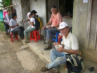 about this with Ringroute in the Subject line. The photo L shows us eating very tasty bowls of bakso, in Kmp Cibedug, at an establishment that must be doing something right because it has been operating in the same place since 1991.
 about this with Ringroute in the Subject line. The photo L shows us eating very tasty bowls of bakso, in Kmp Cibedug, at an establishment that must be doing something right because it has been operating in the same place since 1991.